|
|
|
|
|
Hoping for a bit of advice.... I'm doing Route 66 from Chicago to LA in April. There are lots of websites, you tube videos, blog posts etc online but almost too much information out there. I know that lots of the old road simply no longer exists, and that over the years the route changed as new bits of road were added or improved before the I40 was built and lots of the old route 66 was abandoned, along with the towns on the old road. What I'm looking for is either 1) a detailed map, showing which bits of the old road are still accessible and what attractions / points of interest are on or near the route, or 2) an SD card I can put in a portable satnav like a TomTom that I can take with me, or 3) an ap or similar for my mobile phone. - my only concern about this is possibly really high data costs of using a UK mobile all day every day for 2-3 weeks in the USA. I'd like to see as much as I can on Route 66 (and close to) on this trip. Any advice or experiences of other on RR would be great - thanks in advance. 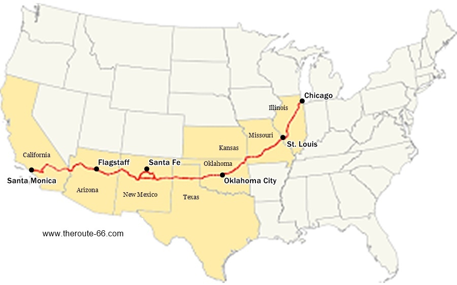 |
| |
Currently driving a 1972 BMW 1602 as my daily. Don't ask about previous cars - there have been way too many and I stopped counting at 160!
|
|
|
|
|
|
|
|
We did a small bit of Route 66 when we were in the States last year. It was well marked from what we saw. Don't ask the locals, we did, they didn't know they were on it!
Regarding data, what I did was wait until we were in our digs then use the free WiFi to download the Google map to our next stop. The only thing you don't get is live traffic updates(obviously). It worked well even in LA and San Francisco.
|
| |
Proton Jumbuck-deceased :-(
2005 Kia Sorento the parts hauling heap
V8 Humber Hawk
1948 Standard12 pickup SOLD
1953 Pop build (wifey's BIVA build).
|
|
|
|
|
|
|
|
I’ve done from St Louis to Chicago, so Chain of Rocks Bridge in Missouri to central Chicago. I think it took us 3 days in 2013. Much of the original R66 is still present and easy to find, but we really struggled to find any resources like you’ve listed. That stretch sort-of follows I55 through Illinois. In some places the old road runs next to I55, a couple of places it’s under it, some places it diverts off, goes through towns, some places there are three different eras of R66 road to choose from. It’s actually all very well signposted through Illinois and easy to follow. There’s a lot of stuff to see like old buildings and museums, preserved historic bits, diners, jails etc. You soon tune in to where the road is going to go because you start to recognise the infrastructure it used and the direction it follows.
R66 used to run right into Chicago and I55 is directly on top of it at that section. Coming into Chicago from the other direction, where we’d been following R66 it was quite obvious where the old road went; but if you’re starting in Chicago, finding the beginning of the old road will probably be the most difficult bit of your journey. After that it should be quite easy.
I’d work on making a list of all the sights along the way in the various states, things you want to visit, diners you want to eat in etc. Don’t be too rigid in your plan ie be prepared to sit back and be flexible. Don’t forget many films you’ve seen were filmed along the way (especially in Chicago) and you might want to take a diversion and see some of those places too. Same goes for food - if you watch anything like Man vs Food or Diners, Drive-Ins And Dives, many of those diners featured are also along the way.
|
| |
|
|
ChasR
RR Helper
motivation
Posts: 10,191
Club RR Member Number: 170
|
|
|
|
|
I'll add one thing.
If you are driving an RV there, a trucker Sat-Nav is imperative to have.
We didn't when we hired ours, and it made getting out of New Jersey (near New York) a royal pain. It was annoying as hell, as most of the parkways were height restricted. Sygic did a good one back then, which made going across the 'states and Canada much less stressful
If it's a car, obviously it's not a concernt. Some good advice above however.
|
| |
|
|
Davey
Posted a lot
 Resident Tyre Nerd.
Posts: 2,197
|
|
|
|
|
I can only echo above. Download offline maps for google is easy and all you loose out on is a bit of traffic info. I've used it every time I've been driving abroad after having some "fun" with a European pack on our old tomtom... Gravel roads are not motorways Tomtom...
|
| |
K11 Micra x3 - Mk3 astra - Seat Marbella - Mk6 Escort estate - B5 Passat - Alfa 156 estate - E36 compact
Mk2 MR2 T-bar - E46 328i - Skoda Superb - Fiat seicento - 6n2 Polo - 6n polo 1.6 - Mk1 GS300
EU8 civic type S - MG ZT cdti - R56 MINI Cooper S - Audi A3 8p - Jaguar XF (X250) - FN2 Civic Type R - Mk2 2.0i Ford Focus
|
|
|
|
|
|
|
|
Back in the day you could data roam for free in the USA on most networks. Some providers now offer things like "bolt on" or "data passport" so you either get additional roaming data packs or you can use your own allowance for free. I was with Three who charge a daily access charge of £5 per day but after that it was unlimited data. I now am on Vodafone and a specific contract which includes free roaming in the USA (and about 84 other countries)
So don't write off your mobile and googlemaps / Waze.
Check your phone provider, or maybe even do what I do in "off limits" countries, which is buy a local PAYG SIM at the airport with like 20GB data on it and use that.
I did my pacific coast road trip in '22 and I did the whole thing using my phone. Even in the desert I had signal. Just rememeber that phones (or satnavs) mounted in the windscreen can get VERY VERY HOT when you are driving in places like California, and they may shut down on you. So think about where to mount it where it will stay cool.
|
| |
Last Edit: Feb 7, 2024 11:59:27 GMT by akku
1937 Austin Street Rod - 1941 Wolseley Not Rod - 1956 Humber Hawk - 1957 Daimler Conquest - 1966 Buick LeSabre - 1968 Plymouth Sport Fury - 1968 Ford Galaxie - 1969 Ford Country Squire - 1969 Mercury Marquis - 1970 Morris Minor - 1970 Buick Skylark - 1970 Ford Galaxie - 1971 Ford Galaxie - 1976 Continental Mark IV - 1976 Ford Capri - 1976 Rover V8 - 1994 Ford Fiesta
|
|